
Gems in the Edge of the Country
-
Date:
30 Apr 2020 -
Author:
KEHATI
DATE: 19 February 2018
AUTHOR: KEHATI
The water is splashing, when the fiber boat that took eight of us drove through the high seas. The color of the sea began to change from green Tosca to blue, a sign that we had crossed deep waters. The vast Pacific Ocean begins to unfold before our eyes.
Twenty minutes has passed, Petta Pier, where we departed, was no longer visible. Meanwhile, Sangihe Island, where the pier is located, seems to leave only the peak of Mount Awu (the highest active volcano on Sangihe), in view. These islands indeed have a number of volcanoes, both on the surface and under the sea. Geological conditions that allow the land of these islands to be so fertile.
That afternoon, we headed for Bukide Island, an island at the northeastern far end of the Sangihe Islands District, North Sulawesi. This is one of about 100 islands that make up the archipelango that are in the waters between Sulawesi Island and Mindanao Island (Philippines). There are two villages on Bukide Island, each of Bukide Village and East Bukide Village, with a total population of approximately 300 families
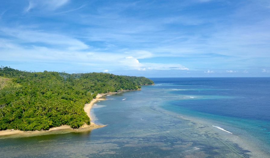
Fifty minutes later, the edge of Bukide Island in the village of East Bukide had filled our view. The blue of the sea turns into a clear green turf. The shallow waters at the edge of the island extend to the bottom. Rows of coral reefs set aside with seagrass beds. Occasionally seen dugong fish (sea cows) swimming between seagrasses. Meanwhile, small fishes of various shapes and colors swarm moving between coral and seaweed. Everything still looks natural.
Syahrul Pansariang (43), a fisherman in East Bukide who drove us, immediately moored his boat on the beach as the boat hit the bottom of the sand beach. Our feet stepped slowly on the clean white sand that adorned the edge of sea water that always looked transparent green.
“We are lucky today. The weather is very sunny. The sky is blue, so the sea water shows its colors, “Syahrul said.
Albar Bulehgelenge (50), Secretary of the village of East Bukide, welcomed us by the beach.
“Come, to my house, we take a short break, eat and drink,” he said kindly.
We immediately rushed to follow the steps of Albar. Small houses with wooden construction are tightly spaced like most of the fishing villages, lined up to meet the eye. The cool breeze of the sea swept the hot afternoon air as we crossed the deserted streets of the island. There are no vehicles passing by. This is because there really are no cars and motorbikes on the island. A situation that keeps the air in this area clean.
The villages formed a cluster near the beach. Entering a few hundred meters into the island, the hills can be seen up to 40 degrees overgrown with dense trees. On that slope, there’s no house in sight. Residents have never cut the forest. Because, they are aware, their survival is very dependent on the preservation of the forest.
“The forest is the source of our spring. Even with dense forests, sometimes we have water shortages during the dry season, especially if the forests are being cut down, “said Syahrul who also serves as the village head in East Bukide.
As is generally the islands in the Sangihe Archipelago, coconut and nutmeg plants also seemed to fill all of Bukide. Two commodities which for hundreds of years have been the main source of livelihood for residents in this region for generations.
Along the roads of the villages on Bukide Island, there were rows of nutmeg or fuli (dried pala skin) dried in the sun to dry. Dried fruit and fuli are then sold to middlemen. Of these commodities, most of the flow of economic activity of citizens revolves.
“Even though it is by the sea, the main income of the residents is mostly from nutmeg and coconut. However, there are also those who go to sea, but they are small, due to the limited fishing gear. Unlike fishermen on Sangihe Island (the main island), “Syahrul said.
Large transportation costs contribute to the high economic costs that must be borne by residents in the islands. This situation erodes the welfare of those who live on these small islands.
After resting for a while at Albar’s house, the eight of us continued our journey to explore Bukide Island. About 15 minutes off the pier of East Bukide Village, we found a small island with a rock hill that rose to as high as 75 meters. Locals call it the name Bukide Batu. Bukide means hill, Batu means stone in Indonesian.
This rock hill is surrounded by white sand banks, and surrounded by shallow waters which are basically seagrass beds and coral reefs. When we climbed to the top of the rock, we could see a row of Sangihe Islands that seemed to stretch out on a colourful water rug. The beauty that is not inferior to the landscape in leading marine tourist destinations, such as Raja Ampat, Sabang, or maybe the Maldives.
In addition to beauty, like most coastal areas in the Sangihe Islands, Bukide Region is still pristine to the beauty and sustainability of its ecosystem. Bukide water is actually a diverse ecosystem, from seagrass beds, mangrove forests, coral reefs, to sandy beach areas. This area has been designated a core conservation zone.
Unfortunately, despite having great potential, this island has not been used sustainably – for ecotourism, for example – which can provide opportunities for improving the welfare of citizens. In fact, this area has many spots that are very suitable for diving tourism activities, coastal ecosystem research, or other marine tourism.
The Sangihe Islands Regency Tourism Office, in fact, did not make this area a tourist destination. “Instead, Kasaraeng Beach, which is uninhabited and located outside the area, has chosen to be a tourist destination. As a result, the beach is unkempt and filled with rubbish, “said Sampiri Non-Governmental Organization (NGO) staff member Saddam Onthony, who accompanied us that afternoon.
Since 2009, KEHATI together with Sampiri, BURUNG Indonesia, and YAPEKA, supported by the Ford Foundation, have carried out an ecotourism and coastal conservation development program in Bukide. Through this program, the community is prepared to be able to manage their own area as an ecotourism destination, maintain its natural preservation, make products that are suitable to the needs of tourism development, organize the area, and prepare lodging in residents’ homes.
“This ecotourism program has become part of the Mid-Term Development Plan of East Bukide Village,” continued Saddam.
Unfortunately, the inadequate sea transportation, promotion and development of supporting infrastructure are still obstacles in developing ecotourism in the Bukide Islands.
“So far, ecotourism visitors in Bukide are still limited to local tourists. Of course, it cannot be expected to have a major impact on the people’s economy. We hope that in the future the government will pay more attention to this potential, “said Saddam.
Scattered potential
Bukide is a small potrait from the Sangihe Islands, an archipelago that actually has the characteristics of a small Indonesia. The islands with a total area of 11,863.58 square kilometers have only 736.97 square kilometers of land. The rest, or an area of 11,126.61 square kilometers, is in the form of the ocean. A characteristic landscape that is very similar to Indonesia, where two-thirds of its territory is water.
Of the more than one hundred islands on Sangihe, only 30 percent are inhabited. The rest are empty islands with no inhabitants. Some of these islands have only been visited when the fishermen landed for a short break. A situation which again reminds us of the Indonesian archipelago, where of the 17,503 islands, 87.62 percent are uninhabited.
Like Bukide, Sangihe in general is also a beautiful and diverse ecosystem. Starting from the white sandy beaches, beaches with mangrove forest cover, rivers, fertile agricultural fields, dense tropical rain forests, to towering volcanoes.
Because most are uninhabited, the islands are still maintained 100 percent authenticity of fauna and flora habitat. The waters around these islands are tosca green, with a combination of translucent sapphire blue like glass, an appearance that indicates there has not been any pollution in the marine ecosystem.
Like Indonesia, Sangihe is rich in natural resources from the sea and the land. In addition to various types of fish, corals, various ornamental fish, and other sea creatures with exotic shapes there.
Sangihe’s underwater also has Mahangetang Mountain, a famous active underwater volcano. The waters around Mahangetang Mountain offer beautiful scenery and natural atmosphere so that it has the potential to develop into a natural marine tourism destination, both for snorkeling and diving.
On land, the islands in Sangihe are rich in agricultural products from several types of trees that flourish, including: spices (nutmeg and clove), coconut, sago, and some local fruits (langsat, durian, mangosteen, jackfruit, and bananas). Nutmeg and cloves are a type of spice that is a commodity of world trade, and it used to be the main reason for the arrival of a number of nations during colonization – mainly Portugal, the Netherlands, and England – to the archipelago.
Even today, nutmeg, cloves, and coconuts — with some of their derivatives — remain excellent. In addition to providing economic benefits, various types of trees also provide ecological benefits, especially as a green cover.
Land surface with forest cover and gardens that are still dense allows the formation of springs in the upstream area. This spring in the mountains has become a source of clean water for residents. The the steep hilly land, form waterfalls, which in some places are used as a driving force for turbines powered by water (micro hydro), as a source of independent energy, although on a limited scale.
In addition to having an independent energy potential, since a long time ago Sangihe also has an independent staple food source, which has the potential to be the key to food security. This food source is not in the form of rice, but sago. Sago trees flourish in Sangihe, starting from the coastal area (wetlands) to the mountains. Sago tree population is relatively high, allowing for the Sangihe community to be self-sufficient in one of these staple foods.
With the territory dominated by waters, it is not surprising that fishermen are the main livelihood of Sangihe Island residents. The sea to the north of Sulawesi is the deep sea, the entrance to the Pacific Ocean to the northeast. That is why the sea around Sangihe is rich with various fish species, including tuna which is excellent in the world’s fish commodities.
The sustainable potential of Sangihe marine and fisheries resources reaches 34,000 tons per year. However, from this potential, only around 14 percent can be utilized. Sangihe fishermen produce various types of fish caught, including: tuna, skipjack, flying fish, decapterus, snapper, grouper, and sharks.
Especially for tuna, Sangihe fishermen prefer to sell it outside the region, especially to Manado. This is because the price and need for tuna in Sangihe is lower. In fact, not a few fishermen from Sangihe sell it to Filipino fishermen. The trick is, the Sangihe fishermen just need to reach the sea border. There, they met with Filipino fishing vessels waiting, and the transaction ensued. Selling their catches to Philippine ships at sea for them is the most practical way. They do not have to bring their fish back home to Tahuna or transport it to Manado. Sangihe fishermen can immediately go home with money from the sale.
Actually, the North Sulawesi Provincial Government has set up a port and tuna market in Bitung. But, the distance from the high seas to Bitung is quite far and it takes a lot of time and fuel costs for the ships.
In addition to the potential of fish in the high seas, Sangihe also has the opportunity to develop marine fish farming in an area of around 346 hectares for several types of fish commodities, including grouper, snapper, lobster, and sea cucumber. In addition, Sangihe waters contain a variety of rare species both for well known (napoleon fish and a variety of ornamental fish) as well as newly discovered species.
Sangihe marine area also has the potential for 250 hectares of seaweed cultivation. However, lately the seaweed in Sangihe is declining because it is often eaten by dugong (sea cows).
Sangihe is also an open laboratory that is rich of natural science. As an area that is geographically a series of Sulawesi Island, the islands in Sangihe also inherit the unique animals of the Wallacea Region. The Wallacea region is a separate geographical area, with no species proximity to Kalimantan Island (in the west) or to animals in Maluku and Papua (in the east). The animal is also typical of wallacea and only exists in that region. Some animals, even, are rare and on the verge of extinction.
This archipelago also still has a relatively wide range of protected forest, which is around 15,885 hectares. In addition, a row of 511 hectares of mangrove forests is also still available. The total forest area in this district is 16,396 hectares.
The protected forest is in the Sahendarumang volcano (1,046 meters above sea level / asl). This forest acts as the main lung of the Sangihe Besar Island. It has a very important role ecologically. This forest provides ecosystem services in the form of water catchment areas that meet the needs of clean water throughout the island and retain landslides and floods.
The existence of volcanoes in Sangihe brings fertility to the land of the islands. Although fertile, Sangihe has only few rice fields because the land surface in this region is too steep and slender for rice farmers.
Almost all the of rice circulating in Sangihe all this time has to be imported from Manado. That means, to get rice, Sangihe residents have to pay more, because there are transportation costs there. In this situation, local staple food commodities, especially sago, have great potential to be developed.
Despite its enormous potential, the Sangihe Islands also bear a number of challenges, including: the use of natural resources that threaten the integrity of primary forests due to the expansion of community plantations and mining activities. These activities have the potential to damage the balance and carrying capacity of small islands. The subsequent impact is damage to coastal waters and coral reef ecosystems due to sedimentation and damage to forest ecosystems.
Dependence on food sources from outside the island is also a threat to local food security. Meanwhile, the potential for environmentally friendly agriculture and plantations, as well as ecotourism has not yet been explored as the basis for excellence in small island natural resource products and is a sustainable economic support for the future. Community awareness needs to be grown so that in utilizing all their natural products, they will pay attention to their long-term sustainability.
As with the efforts of caring for civilization, conservation efforts are not something that happens once and completed afterward. Conservation is work that never ends. What has been done by various parties in the effort to care for the sparkle of Sangihe is not the end. This is the beginning for Sangihe’s wealth to be sustainable.
And, the day was getting late when we left Bukide. The roar of the tides is following the pace of our boat. Heading to the other side of the jewel at the edge of this country. (continued)